FLOOD RISK MANAGEMENT APPROACH IN FRANCE CONTEXT
Le Havre is located at the north of France on the Seine estuary (Normandy region). Le Havre metropolitan area is 293.851 inhabitants for 678 km². More than 60% of inhabitants live in Le Havre city (178.769 inhabitants in 47 square kilometer) (INSEE, 2010). And it is the second largest Harbor in France. based on the framework of PPRNP (Plans de Prévention des Risques Naturels Prévisibles). The state administration aim was to create a single planning document that would replace all the PSS, Art. R111-3 perimeters and PER (Plan d’Exposition aux Risques Naturales Prévisibles) that existed. None of those procedures had really been successful and implemented locally. Hence, the PPRi aim is to be a simpler tool to identify flood prone areas and impose planning regulations on them (M. Amalric, S. Bernier, M. Fournier, J. Serrano, L.Verdell 2008). The state administration is responsible and carries out the studies and mapping of the PPRi. Hence, it is a planning document (maps and rules) which constraints local planning documents). The prefect’s administration (head of the should be planned33. Then, the state administration through the DDE (Direction Départementale de l’Equipement) carries out the project. A negotiation phase is planned with the local authorities and a public inquiry before the PPRi is approved by the prefect34 (M. Amalric, S. Bernier, M. Fournier, J. Serrano, L.Verdell 2008). At the local level, concerns to the observation of the constraints imposed by the PPRi as well as the willing to develop the territory, there is a main instrument as the PLU (Plan Local d’Urbanisme)35 which is a strategic document must follow what defined in the local PPRi that cancelled the former procedures (M. Amalric, S. Bernier, M. Fournier, J. Serrano, L.Verdell 2008).
Stakeholders of Le Havre in Flood Risk Mitigation
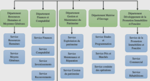
CODAH is defined by 17 communes being Le Havre one of them. The aim is to help the population in several areas such as waste management, water management, transport, and information about major risks, hygiene and health, housing, economy, tourism, sports infrastructure. Related to the floods risk CODAH leads the development of guides about flood risk into the city addressed to the community. CODAH is defined by 17 communes being Le Havre one of them. The aim is to help the population in several areas such as waste management, water management, transport, and information about major risks, hygiene and health, housing, economy, tourism, sports infrastructure. Related to the floods risk CODAH leads the development of guides about flood risk into the city addressed to the community. The urban department in the town hall is addressing PLU (Plan Local d’Urbanisme) which is focused to identify flood risk areas into the city and provide it of rules such as: minimum height for ground floors, and forbidden areas to build underground parking.
The University of Le Havre is developing different tests to verify or contrast water sea levels in order to better understand flood events that happened during 1982, 1983 and 1984 in Saint François neighborhood. The ORSEC (Organisation de la Réponse de Securité Civile) has been developing, through hydrodynamic modeling, statistics to analyze the sea behavior during the last decade that; as main results they have proposed a chart according to sea tide: Optimistic when water from the sea overflows around 40 cm height, Pessimistic when water from the sea overflows around 60 cm height, and Extreme when water from the sea overflows around 1 meter height. The MDS (Spread of Modeling Methodology) focusing on designing a communication process in terms of sea submersion, therefore they are promoting tools to spread information about sea overflow and their phenomena or different consequences. Just as a historical date: Le Havre was established in 1517 and the first flood event happened in 1525. Therefore we can see that this area has lived with the water since its foundation, as well as with several other factors such as rainfall, the river, the sea, and the stream.

